Pulpis CastleFrom the village Square of Santa Magdalena de Pulpis, the hiker goes in the direction of the towns cementery. Passing the cementery, you immediately find the signal that indicates the beginning of the itinerary, a route abundant with various crops, olive, carob and almond trees.
The trail becomes narrow and you make a pleasant climb through a shady ravine. The surrounding landscape is remarkable, which is characterized by the presence of old ovens which have been converted into shelters.
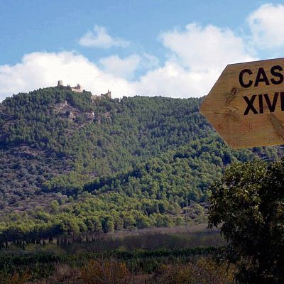
The last stage is a steep path to get to the Pulpis Castle, an old Moorish fortress of the X – XI century that maintains its grandeur and beauty despite being in ruins. The building maintains its great tower called Torre Homenaje and also the original underground well.
- Lenght: 4 km
- Duration: 1h
- Type of route: Track
- Dificulty level: Medium
- Departure: Santa Magdalena
- Arrival: Castillo de Pulpis
Mas del Senyor, Clot de Maig, Torre BadumThe route starts in the Font Nova urbanization, where the signal indicates the entrance to the Natural Park of Sierra de Irta. On this track, you reach Mas del Senyor, an area full of elm trees where you can take a rest and contemplate your surroundings.
Regaining your energy, you will return by the same road until the intersection of the Badum Tower taking the path that leads to the Clot de Maig area. Continuing downhill you reach the coast, where the hiker can choose between two paths. To the right within a few meters away, is the only sandy beach that exists in the sierra, perfect to stop and have a swim. The other option is to take the path on the left and visit the Badum watchtower with spectacular views of the Mediterranean Sea. The walker returns to the start point following the same itinerary.
- Lenght: 12 km
- Duration: 4 h
- Type of route: Track
- Dificulty level: Medium
- Departure: Urbanización Font Nova
- Arrival: Urbanización Font Nova
Xivert CastleThis route starts in the church square of Alcala de Xivert .The route is divided in two: the Corral of la Paridera is situated on the left hand side and the Corral de la Creuis situated opposite passing under the AP-7. If the hiker chooses this last option, he will find beautiful almond and orange trees. When starting the climb towards the castle via Assagador de la Serra, the hiker can contemplate the spectacular views of the Estopet and Santa Lucía’s chapel, and the breathtaking views of the valley which lay at your feet .
The route continues through the Assagador taking you directly to the Corrales de Marimon and Manro. At this point, the hikers return begins by climbing up to the Ametlers lookout point, where the best views of the park can be seen. The following visits are La Bassa and el Corral de la Viuda.
Continuing the walk through the forest track, the hiker will find a cross marked on the left handside which takes you down to the Rambla del Ameler. Once again, you climb up to the castle through a firewall called Dragon Khan. Once you have reached this point, you’ll begin your descent via a foot path to the Corral de la Paridera, which takes you back to the starting point.
Inside the Xivert Castle, the hiker will be able to choose between different routes with more or less difficulty levels.
- Lenght: 23,3 km
- Duration: 7 h 40 min
- Type of route: Track and pathway.
- Dificulty level: Hight
- Departure: Alcalá de Xivert
- Arrival: Alcalá de Xivert
Circular route around Xivert Castle and Corral de la ParideraThe climb to the Xivert Castle is made via the footpath named the Cara de Mahoma, forested with vine, orange, carob, almond and olive trees. Once you are in the fortress, you’ll be amazed by the fantastic views of the valley where Alcala of Xivert is situated. Surely you’ll take photos!
Once at this point, the hiker will take the path situated on the left hand side behind the Les Llanes, where he will continue through the Assagador de la Serra until he reaches the descent called the Corral de la Paridera, arriving back the starting point.
- Lenght: 12,7 km
- Duration: 4 h 13 min
- Type of route: Track and pathway
- Dificulty level: Medium - low
- Departure: Alcalà de Xivert
- Arrival: Alcalà de Xivert
Circular route around Xivert Castle and Corral de la CreuThe route begins through the Cañada Real del Clot de Diumenge and walking between orange and almond trees you’ll reach the Corral de la Creu. Amongst the pine trees via the Assagador de la Serra, you will arrive at the Xivert Castle, whilst enjoying the breathtaking views of the valley of Estopet and the Santa Lucia’s chapel. After visiting the fortress, the hiker can return to the town through the Cara de Mahoma, a foot path which takes you through a pine forest that descends through the castle and Corral de Les Llandes. The descent then continues amidst fields of crops.
- Lenght: 11,5 km
- Duration: 3 h 49 min
- Type of route: Track and pathway.
- Dificulty level: Medium
- Departure: Alcalá de Xivert
- Arrival: Alcalá de Xivert
Santa Lucia – Torre Ebri – B Carrera – Coll de la Palma – Barranc de la ParraThe route’s starting point is the Vista Alegre's Square. Once you’re out of the old town, you’ll begin a steep climb up to Santa Lucía's chapel, but halfway up there is a resting area where you can have a short break to recover and also see the fantastic views. Then, you’ll continue climbing up until you reach the chapel, where you’ll see the Nature park Prat de Cabanes, Ribamar coves and on a clear day, the Islas Columbretes Nature park. Furthermore, the hiker will discover the Valley of Estopet, Castellon Massif and the Nature parks of Sierra de Espadan, Las Palmas desert, Benifassa or Penyagolosa .
You will continue through the pathway to the left until you reach the access to Ebri's Tower. At one point on route, there is a viewpoint that offers you a fantastic panoramic view of the park, Alcoceber and the beaches. Once you have visited the tower, you will arrive at Carrera's ravine , leaving to your right the Cañada Real del Clot de Diumenge's ravine, which will take you to the coast and to Pico de Campanilles.
Descending through Carrera’s ravine and once you have reached the bottom, you'll take the pathway to the right until you reach the Ametlers main track, continue via this track to climb the Coll de la Palma. Here, you will climb towards the Pico of Campanilles and a few metres before, you turn left to go down to the coast via the Font de la Parra’s ravine. When you reach the bottom of the ravine, there is path that takes you back to the starting point of the route, where you’ll be able to see the unspoilt coves of la Sierra de Irta’s Nature park.
- Lenght: 26,5 km
- Duration: 8 h 45 min
- Type of Route: Track and pathway
- Dificulty level: Hight
- Departure: Plaza Vista Alegre
- Arrival: Plaza Vista Alegre
- This route offers you three different levels of difficulty.
1. Santa Lucía
The route begins outside of the tourism office in Vista Alegre's Square. After leaving this area, the climb to the chapel begins. The climb is quite hard, nevertheless halfway up there is an area where you can stop to rest and contemplate the views.
Your climb continues up, where you will have wonderful views of Prat de Cabanes Nature park, the Ribamar coves and the Islas Columbretes Nature park too. You'll be amazed by the views of the Valley de Estopet, Castellón’s massif, Sierra de Espadan, Las Palmas desert, Tinenca de Benifassa or Penyagolosa.
- Lenght: 4,9 km
- Duration: 1 h 38 min
- Type of Route: Track, pathway and road.
- Dificulty level: Medium - high
- Departure: Tourism office in Vista Alegre's Square
- Arrival: Tourism office in Vista Alegre's Square
2. Senda de las Calas
The route begins in the Cala Blanca cove, at the beginning of the promenade that takes you to the Faro Blanco (White Lighthouse) and coves. To access the promenade you've got to take the first crossroads to Alcoceber, from the national 234, specifically the one on the left that indicates North-Alcoceber. Here, you'll be able to park your car.
The route, about 2 km (one way), starts on the promenade and after passing the impressive lighthouse, the hiker reaches some stone and sandy coves situated in Irta's Nature Park.
From the Cala Blanca's promenade, you have to walk over the wooden footbridge towards the north and the Faro Blanco (White Lighthouse) that will take you approx. 10 minutes. Next, you'll cross the Cala Mundina ravine and continue along the pathway marked in red. The route flows between pines, scrubs and houses till you reach a pebbly cove. From here, you will have to walk a few metres until you reach a lovely sandy cove (20 minutes walk from the lighthouse until the sandy cove close to Ribamar).
- Lenght: 4 km
- Duration: 1-2 h
- Type of route: Pathway
- Dificulty level: Low
- Departure: Blanca's cove
- Arrival: Cove near Ribamar
3. Font de la parra
To access this route you need to go by car until you reach the bottom of the Font de la Parra ravine, where you'll start the route.
This is a pathway that features abundant vegetation, shaded areas and lots of pines trees. Without a doubt, a lovely area for walking.
The climb continues and the hiker will find water well, that is more than likely connected to the Font de la Parra.
- Lenght: 7,6 km
- Duration: 2 h 33 min
- Type of route: Pathway
- Dificulty level: Medium
- Departure: Font de la Parra´s ravine
- Arrival: Font de la Parra