The 5 best hiking trails in the province of Alicante
The fantastic climate that the Costa Blanca enjoys throughout the year, with mild temperatures and endless sunny days, makes the province of Alicante the ideal place for hiking. Have you tried it yet?
Without a doubt, it is a sport that is gaining more followers every day due to its enormous potential to enjoy the most varied and spectacular landscapes of the Mediterranean at your own pace, without haste. Losing yourself along the best routes and hiking trails in Alicante is a gift of nature that you should take advantage of on your next vacation.
Here is our selection! These are the 5 hiking routes in Alicante that you must try out at least once in your lifetime:
Coastal path (Villajoyosa)
![]() Distance: 4 kilometres
Distance: 4 kilometres
![]() Time: 2 hours
Time: 2 hours
![]() Difficulty: Easy
Difficulty: Easy
A few meters from the Poniente area, in Benidorm, a stretch of gentle cliffs, pine forests and small coves with crystal clear water begins, separating the town from the skyscrapers of the beautiful town of Villajoyosa. This idyllic landscape is the setting for a fantastic route for the whole family, low difficulty and offering a multitude of different experiences. Sounds good right?
The route begins with the ascent to the Torre del Aguiló, an old defence tower from the 16th century, and then continues with a relaxed descent along the coast on a smooth and stable path that offers the possibility of taking different detours to some coves such as Racó de Conills or Cala Fonda where you can cool off and take a break. At the end of the route, and very close to the town of Villajoyosa, Playa del Torres, surrounded by a sea of eucalyptus trees, completes this beautiful path.
The estimated time to cover the total 4 kilometres covered by the walk is two hours, with enough time to enjoy the views and make stops. At the top of the Torre de Aguiló there are tables for picnics. The starting point of the route is on Calle Tramontana, in the La Cala area, within the municipality of Villajoyosa.
Circular route of the Sierra de Bernia (Altea)
![]() Distance: 9 kilometres
Distance: 9 kilometres
![]() Time: 4-5 hours
Time: 4-5 hours
![]() Difficulty: Medium
Difficulty: Medium
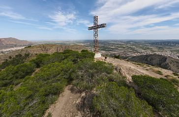
The Sierra de Bernia is located a few kilometres from Benidorm and acts as a natural border separating the Marina Baixa from the Marina Alta. Its steep profile featuring a huge hole (the “Forat”) in the centre of the rock and its incomparable views over the bay of Altea and the Benidorm skyline are more than enough reasons not to miss this jewel of nature.
The circular route borders the mountains for a total of 9 kilometres, so you will have to invest around 4 or 5 hours to complete the route. It is an irregular path, so the difficulty of the route at some points can be medium, and it is highly advisable to wear suitable footwear. The starting point is in the hamlet of Casas de Bernia, where there is a large public car park, belonging to the municipality of Jalón.
Undoubtedly, the great attraction of this route, from which you can enjoy the sea at all times despite the distance, is the colossal “Forat” de Bernia and its picture postcard panorama. To reach this viewpoint that pierces the mountains you will have to go through a small natural tunnel in which it is necessary to even bend over. An adventure!
El Hondo Natural Park (Elche)
![]() Distance: 775 meters
Distance: 775 meters
![]() Time: 20 minutes
Time: 20 minutes
![]() Difficulty: Easy
Difficulty: Easy
Located in the south of the province of Alicante, very close to Hotel La Zenia, The Hondo Natural Park is an ideal place for a family hiking route. In fact, depending on your physical form or who you travel with, you will be able to discover this very special ecosystem through not one, but up to 4 routes of different duration.
Located on the land that formerly occupied the Elche lagoon at the mouth of the Vinalopó River, El Hondo is a huge wetland hidden behind the reed beds, offering the image of a large natural and wild lagoon, surrounded by a series of ponds, salt marshes, fields of crops and palm groves that make up an exceptional landscape. In addition, it is the habitat of countless birds of great beauty such as flamingos, herons or ducks of more than fifteen species.
Although it is a very flat landscape and easy to walk, the different durations of the routes that cross the Natural Park will offer you a great variety of experiences to get to know these wetlands with more or less depth. The shortest is the Yellow Route (circular 775 meters) that takes about 20 minutes and runs around the Interpretation Center of the park, very close to the AP7 (exit 730). Two other more extensive routes start from the same point and enter the ecosystem. They are the Green Route (circular of 3.75 kilometres and take approximately 1 hour) and the Blue Route (linear of 16 kilometres and takes about 4 hours). In addition, there is also the Red Route at the other end of the park that extends about 5 kilometres through the interior of the wetlands which is necessary to reserve.
Cliff route (Benitatxell)
![]() Distance: 2.3 kilometres
Distance: 2.3 kilometres
![]() Time: 2 hours
Time: 2 hours
![]() Difficulty: Easy
Difficulty: Easy
Without a doubt, the Path of the Cliffs is one of the most beautiful hiking routes in the province of Alicante and even in the entire Mediterranean. It seems impossible that there is a path on the edge of the cliffs, sheltered by the impressive rocky masses of the Marina Alta, linking two beaches as special as the touristy Cala del Moraig and the wild and picturesque Cala Llebeig.
It is a simple route, although at certain times it is not very suitable for people with vertigo. Its 2.3 kilometres long are covered back and forth in a couple of hours, although it is advisable to invest more time and enjoy the stops and viewpoints that dot the entire route. The starting point is in the Cala del Moraig car park, where you have to head south. There are signs that indicate the exact place where the trail begins.
A route with a taste of the sea 100% perfect for a sunny day!
The source of the Vinalopó River (Banyeres de Mariola)
In the middle of the Mediterranean riberian forest, within the Sierra de Mariola Natural Park, the Font de la Coveta route, in reference to the small cave from where the Vinalopó river flows, is a paradise for those who are lovers of the mountain. And that seek the tranquillity of a path that runs to the beat of the whisper of that fragile stream that is the birth and first kilometre of this river.
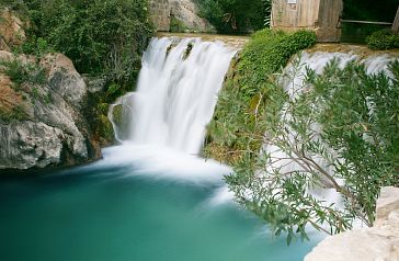
The route begins at the Natural Park visitor centre, an old farmhouse known as Mas d'Ull de Canals. From there a forest track starts up to the riverbed, where a beautiful path parallel to the river's course begins. One of the most beautiful points of the route is in the Toll Blau, a lagoon watered by a monumental waterfall. What a magical place!
The total distance of this linear route is 7 kilometres, so it can be covered in about three hours. It is a very simple terrain perfect for all audiences. But pay attention! This is an ideal place to relax and enjoy nature, although always paying special attention to the natural environment, since it is a place of high ecological value because it is the only stretch of the river without alterations by human activity.
Have you heard of these Alicante hiking trails? If you are thinking of visiting the Costa Blanca and enjoying a few days of rest in any of the hotels that Servigroup puts at your disposal in Benidorm, you will surely include hiking in your plans. A different way of getting to know the most special landscapes of the province of Alicante breathing fresh air and experiencing first-hand the privileged climate of this beautiful corner of the Mediterranean.